Chase and I will be hiking the popular Nantahala Basin Loop trail, which encompasses about 18 miles of the AT from Deep Gap to Glassmine Gap. I found this hike on Everytrail and it seemed to be the perfect hike for what we needed: a multi-day loop with a variety of terrain. We have a few options regarding the actual route of the hike, and I’d like to present those options here:
Option 1:
Long Branch Trail from Standing Indian Campground to meet the AT at Glassmine Gap (2.0 miles). Take the AT south to Albert Mountain, with the option to camp on the summit (3.5 miles), or continue to either Betty Creek Gap (5.7 miles) or Carter Gap (9.4 miles) depending on how we feel. I’m expecting a short day and the 5.5 miles to Albert might be enough to exhaust us completely. The next day, we could hike from the summit of Albert to Carter Gap (6.2 miles) , Betty Creek Gap to Beech Gap (6.9 miles), or from Carter Gap to Standing Indian (6.1 miles). Day 3 would encompass either Carter Gap to Standing Indian (6.1 miles) , Beech Gap to Standing Indian (2.9 miles), or taking the Lower Ridge Trail from the summit of Standing Indian back to the campground (4.2 miles). The 4.2 miles from the summit of Standing Indian would make for a short half-day hike on the last day. This would be 22 miles total over possibly 3-4 days!
Option 2:
Kimsey Creek Trail from Standing Indian Campground to Deep Gap (3.7 miles). Take the AT north to Standing Indian Mountain (2.4 miles) with the option to camp on Standing Indian. We could also push on to Carter Gap another 6.1 miles from the summit of Standing Indian, but I doubt we will. From there, Day 2 would be Standing Indian to Carter Gap (6.1 miles), or Carter Gap to Albert Mountain (6.2 miles). Albert Mountain to Glassmine Gap is only 3.2 miles, and the exit trail along Long Branch is only 2.0 miles, making for a short Day 3/4. This trail route is 23.6 miles!
Option 3:
Lower Ridge Trail straight up to Standing Indian Mountain (4.2 miles), where we could camp or press on another 2.9 miles to Beech Gap. On Day 2, from Standing Indian to Carter Gap is 6.1 miles, and our hike would be much of the same as Option 2 for the final miles. If we make it to Beech Gap, Betty Creek Gap is 6.9 miles away, and our third day would encompass the steep climb up Albert Mountain (2.5 miles) and camping at Long Branch Shelter (4.9 miles total from Betty Creek), and a short day from Long Branch Shelter back to Standing Indian Campground (2.8 miles). This would add up to a total mileage of 21.7 miles!
I’m personally leaning toward Option #2! This option will show us the trail as we will see it when we set off next year, with the opportunity to summit two mountains and camp on each. The mileage is also uniform, which I think I will benefit from as this will be my first backpacking trip.
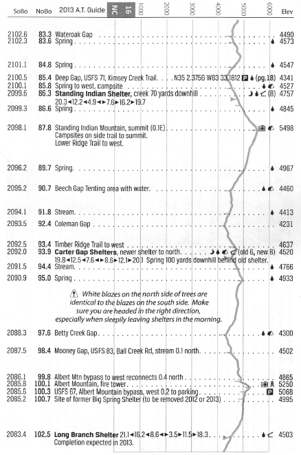
AWOL’s A.T. Guide (2013 edition) shows the terrain for this section hike on page 16, which will be very convenient for us. I highly recommend this book to anyone hiking the Appalachian Trail, thru- or not.
Overall I’m really stoked to finally get out on the trail and test out my gear. I really wish we could bring the dog, but the logistics didn’t work out this time since we will be spending time after our hike with friends and family.
I will be posting lots of pictures and probably initial gear reviews after the hike!
No comments:
Post a Comment